Nanotechnology in Geographic Education
Nanotechnology in Geographic Education: Nanotechnology, the science of manipulating matter at the atomic and molecular scale, has revolutionized various fields, including medicine, engineering, and environmental science. However, its integration into geographic education is an emerging trend that holds immense potential. This blog explores how nanotechnology enhances geographic learning, its latest applications, and real-world examples that educators can incorporate into their teaching strategies.
At TeacherEducator.com, we aim to bridge cutting-edge technology with modern pedagogy, ensuring educators stay ahead in an ever-evolving academic landscape.
What is Nanotechnology?
Nanotechnology involves the manipulation of materials at the nanoscale (1-100 nanometers). At this scale, materials exhibit unique properties that differ from their bulk counterparts, enabling innovations in various industries.
Why is Nanotechnology Important in Geography?
Geography encompasses the study of Earth’s physical features, climate, and human-environment interactions. Nanotechnology contributes by:
- Improving environmental monitoring (e.g., nanosensors for pollution detection).
- Enhancing geospatial data collection (e.g., nano-satellites for high-resolution imaging).
- Supporting sustainable resource management (e.g., nanomaterials for water purification).
How Nanotechnology Enhances Geographic Education?
Interactive Learning with Nanotech Tools
- Virtual Labs: Students can simulate nanoscale geographic processes (e.g., soil erosion at molecular levels).
- Augmented Reality (AR) Maps: Nanotech-enabled AR provides real-time geographic data overlays.
Improved Data Accuracy
- Nanosensors in fieldwork help collect precise climatic and geological data.
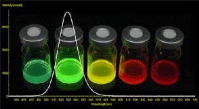
- Quantum Dots enhance satellite imagery for better geographic analysis.
Sustainability Education
- Teaching nanotech-based solutions for climate change (e.g., carbon nanotubes for CO₂ capture).
Latest Applications of Nanotechnology in Geography
A. Environmental Monitoring
- Nanosensors detect pollutants in air and water with high precision.
- Example: Graphene-based sensors monitor oil spills in oceans.
B. Precision Agriculture
- Nano-fertilizers improve soil health and crop yield.
- Example: ZnO nanoparticles reduce pesticide usage in farming.
C. Disaster Management
- Nano-coatings for earthquake-resistant infrastructure.
- Example: Carbon nanofibers in building materials enhance durability.
D. Climate Change Mitigation
- Nanomaterials for efficient solar energy harvesting.
- Example: Perovskite solar cells with higher efficiency rates.
Real-World Examples of Nanotech in Geographic Studies
1. NASA’s Use of Nanosatellites
- CubeSats equipped with nanotech sensors provide high-resolution Earth imagery.
2. Smart Dust for Ecological Research
- Tiny wireless sensors (Smart Dust) monitor microclimates in forests.
3. Nanotech Water Filters
- Example: Tata Group’s Swach water filter uses nano-silver for purification.
4. Self-Healing Concrete for Urban Geography
- Nano-concrete repairs cracks automatically, reducing maintenance costs.
Challenges and Future Prospects
Challenges
- High costs of nanotechnology implementation.
- Ethical concerns over nanoparticle environmental impact.
Future Trends
- AI + Nanotech for predictive geographic modeling.
- Biodegradable nanomaterials for eco-friendly applications.
Conclusion
Nanotechnology is transforming geographic education by enabling real-time data collection, sustainability solutions, and interactive learning tools. Educators must embrace these advancements to prepare students for a tech-driven future.
